Overview
Things to Know
What Makes Mũi Điện (Cape Varella) Special
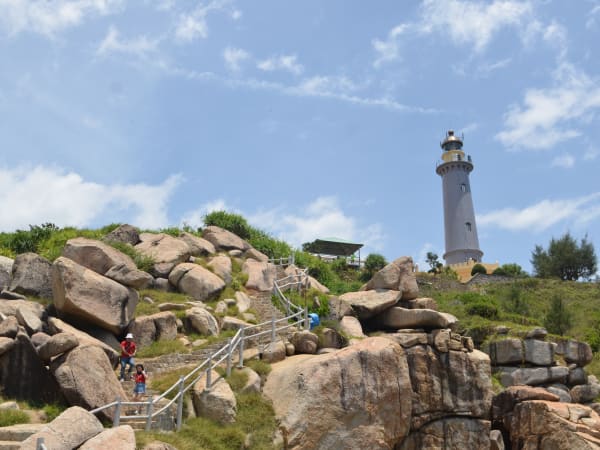
Mũi Điện, known historically as Cape Varella after the Portuguese name given by early maritime navigators, is a bold headland rising 110 metres above the South China Sea at the northeastern corner of Phú Yên province. A working lighthouse has stood here since the French colonial period, and the cape remains an active navigation point for shipping moving along Vietnam's central coast. Mũi Điện is widely described in Vietnamese geography as the easternmost point of mainland Vietnam, though strictly speaking this distinction belongs to Mũi Đôi in Khánh Hòa - what Mũi Điện offers is what Mũi Đôi cannot: a fully accessible cape by road, with panoramic sea views, a lighthouse with a history, and the adjacent Bãi Môn beach below. For the Vietnamese long-distance riding community, Mũi Điện is the standard reference for the eastern extreme - accessible, dramatic, and at the furthest eastern reach of the main coastal highway.
Gallery


How to Get There
🚗 Getting There
Mũi Điện is reached via the coastal road from Đại Lãnh village, itself on Highway 1 between Nha Trang (60km south) and Tuy Hòa (40km north). From Đại Lãnh, the road to the cape runs 8km through increasingly dramatic coastal scenery before reaching the lighthouse access gate. Motorbike is the standard approach. Đại Lãnh is served by intercity buses on the Nha Trang-Tuy Hòa route.
What to Expect
👀 On the Ground
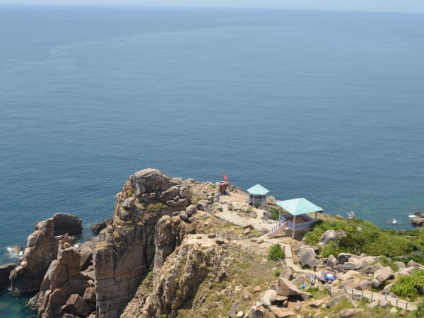
The road to Mũi Điện climbs steadily from Đại Lãnh village along the base of the headland, with the bay visible to the left and the cliffs rising to the right. The lighthouse compound sits at the top of the cape, and walking the surrounding area reveals views north toward the mountains of Phú Yên and south down the coast toward Đại Lãnh and eventually Nha Trang. The sea below the cape is deep and exposed - on windy days the surf against the rock base is considerable. The cape walk takes 30-45 minutes to cover properly, with rest points at the lighthouse and at the various viewpoint spurs. Bãi Môn beach is accessible by a trail descending from near the lighthouse - this hidden beach directly below the cape is the natural complement to the cliff-top experience.
Travel Tips
🧳 Tips
Mũi Điện is a natural stop on any coastal motorbike route between Nha Trang and Quy Nhơn or Đà Nẵng. The half-day structure works well: arrive early for sunrise or morning light, walk the cape, descend to Bãi Môn for a swim, and return to Đại Lãnh for lunch before continuing north or south. The fishing village of Đại Lãnh below has some of the freshest and cheapest seafood on this stretch of coast - the local tuna and barracuda caught just offshore are a reason to extend the stop by an afternoon.
Insider Tips
Based on real traveler experiences and commonly mentioned advice from multiple visitors.
FAQ
Common questions from travelers who've visited this place.
What is the entrance fee?›
How do I reach the lighthouse?›
When is the best time to visit?›
Nearby Locations
Explore more things to do like this around Vietnam