Vietnam doesn't begin at its coastline.
It begins at places most people never think to visit - where two of Southeast Asia's greatest rivers quietly cross the border and start their journey through Vietnamese soil.
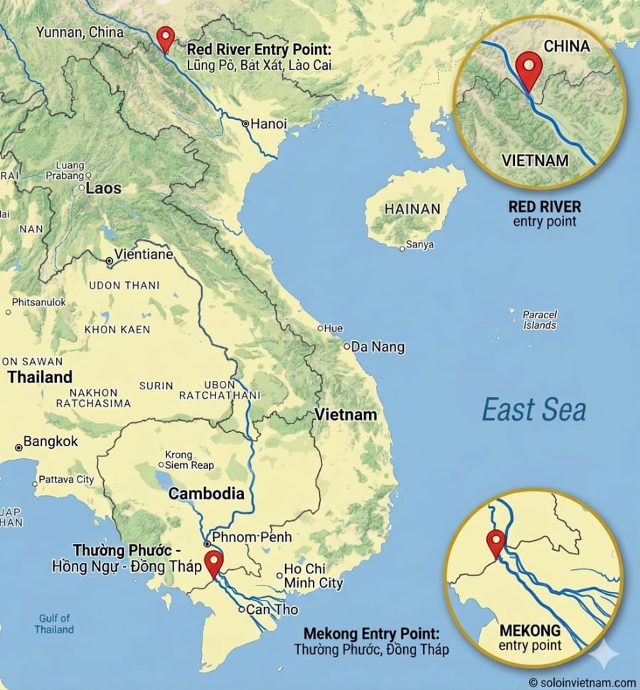
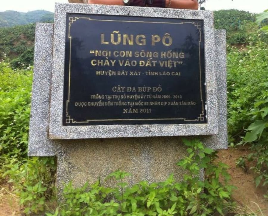
The Red River enters Vietnam at Lũng Pô, a remote corner of Lào Cai where the mountains of southern China slope down to meet the frontier. The Mekong crosses at Thường Phước, Đồng Tháp, where flat floodplains stretch from Cambodia into the delta.
I've been to both. Both times, without planning it, I arrived around September 2nd - Vietnam's National Day. Looking back, there's probably no better time to stand at places like these.
The Geography
To understand why these two places matter, you need to zoom out.
The Red River originates in Yunnan Province, China, where it's known as the Yuan River. From there it flows south through steep mountain valleys, carrying the distinctive red sediment that gave it its name - and that has colored the entire Red River Delta for thousands of years. Over 1,200km in total length, but only around 510km of that flows through Vietnam, from Lũng Pô all the way to the coast of Thái Bình Province.
The Mekong is longer by far. Nearly 4,350km from the Tibetan Plateau, passing through six countries before reaching Vietnam:
🇨🇳 China → 🇲🇲 Myanmar → 🇱🇦 Laos → 🇹🇭 Thailand → 🇰🇭 Cambodia → 🇻🇳 Vietnam
By the time it crosses into Vietnamese territory, it carries the sediment of an entire continent - and the story of dozens of civilizations that have lived along its banks.
Two Rivers, Two Civilizations
The Vietnamese didn't just live beside these rivers. In many ways, they were shaped by them.
The Red River is the cradle of Vietnamese civilization. Over 4,000 years ago, early Vietnamese people settled the fertile delta that the river built. The Hùng Kings' Văn Lang state, then Âu Lạc, then a thousand years of Chinese rule - all of it unfolded on the land that the Red River created. Thăng Long, modern-day Hanoi, was chosen as the capital partly because of its strategic position along this river.
The Mekong tells a different story. The Mekong Delta wasn't always Vietnamese territory. For centuries, it belonged to the kingdoms of Phù Nam and then Chân Lạp - the Khmer people. Vietnamese settlers only began moving into the region in the 17th century, gradually opening up the wetlands that the river had formed. By the 18th and 19th centuries, the Mekong Delta had become an inseparable part of Vietnam.
Two rivers, two very different historical journeys - but both flowing toward the same sea.
Lũng Pô - Where the Red River Enters Vietnam
September 2013. I had just graduated from university and was making my first real journey across Vietnam - touching all four extremes and the highest peak. Lũng Pô wasn't in the original plan. On the way up to Y Tý, our group looked at the map and decided: let's just go.
Back then, Lũng Pô barely existed on any tourist map. No flagpole. No signs. Just a dirt path leading down to the riverbank, and the feeling of standing somewhere very few people had thought to come.
The most striking thing wasn't the border marker. It was the color of the water.
Right at the confluence, the river ran in two distinct colors side by side: one channel clear green, the other heavy red. The line between them looked almost drawn - as if someone had ruled it into the water. It took a moment to understand: this was where Lũng Pô Stream meets the Red River, two sources that hadn't yet had time to mix.
On the bank stood a dead red-leafed banyan tree. Dry trunk, roots still gripping the soil - as though whoever planted it there had done so not for shade, but to hold on to this piece of borderland. The tree didn't survive. But the roots were still there.
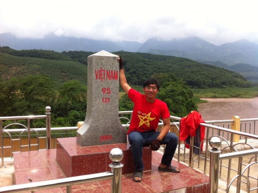
Standing at Lũng Pô on September 2nd, looking across to the Chinese bank. The river was narrow here - narrow enough that you could feel the two shores holding it in, as if the water needed to gather itself before beginning the long journey south. In Hanoi, millions of people were in the streets for National Day. Here, there was only the sound of the current and the border.
Today, Lũng Pô has changed - a flagpole has been erected, the road in is easier, and weekends bring a steady stream of visitors. But the feeling of standing at the first point where the Red River touches Vietnamese soil hasn't changed.
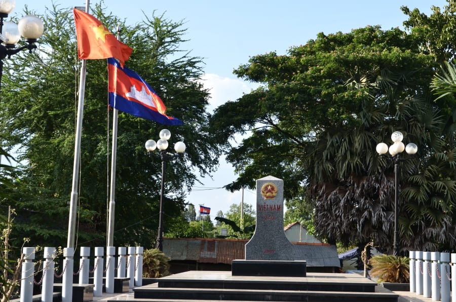
Thường Phước - Where the Mekong Enters the Vietnamese Delta
September 2017. Another National Day holiday - I was traveling through the Mekong Delta during flood season, and Thường Phước was along the way. (Read more: Flood Season in the Mekong Delta - coming soon)
The Mekong Delta in September is a different world. Water floods the fields, village roads disappear beneath the surface, and people move by boat more than motorbike. The whole delta seems to breathe - contracting and expanding with the rhythm of the annual floods. This is the Mekong doing exactly what it has done for thousands of years: feeding the delta with water and sediment.
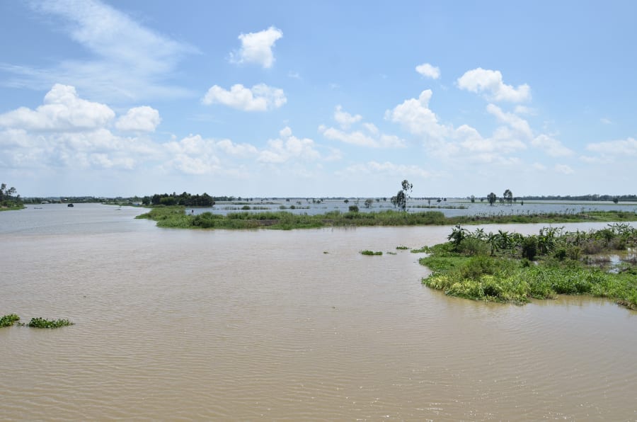
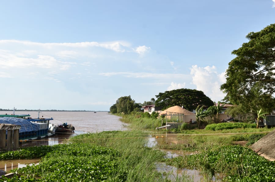
Border markers 240 and 246 sit at Thường Phước, Hồng Ngự District, Đồng Tháp Province - right on the Cambodian border. This is where the Mekong officially enters the Vietnamese delta, before flowing into the Tiền and Hậu river system and on toward the sea. At the border crossing, people moved back and forth as they would on any ordinary day - nothing to signal that this is one of the most geographically significant points in the country.
There's nothing dramatic here. No mountains. No sharp division in the water like at Lũng Pô. Just a wide, slow river and water heavy with red sediment - the color of thousands of kilometers of earth from Tibet, Yunnan, Myanmar, Laos, Thailand, all carried here. Everything the river has passed through shows up in that color.
It doesn't need to be dramatic to carry weight.
There's something I only realized later: I had been to both ends of this river.
At Thường Phước in September 2017, I stood where the Mekong enters the Vietnamese delta. Then on April 30th, 2014 - another national holiday - I stood at the other end, where the river finishes its journey and dissolves into the South China Sea through nine river mouths the Vietnamese call Cửu Long: the Nine Dragons.
Between those two points: about 250 kilometers - and an entire civilization.
From Thường Phước, the Mekong flows into the Tiền and Hậu river system, through the delta it created. Thousands of years of sediment from Tibet, Yunnan, Myanmar, Laos, Thailand - carried here, building the most fertile rice-growing plains in Southeast Asia. The river irrigates millions of hectares of paddy fields, sustains tens of millions of people, and has made Vietnam one of the world's largest rice exporters.
All of that begins here - in the red, sediment-heavy water quietly crossing the border at Thường Phước on an ordinary September morning.
Want to follow the Mekong's full journey through Vietnam? Chasing the Nine Dragons: All Nine Mekong River Mouths is the next chapter.
Two Entry Points, One Country
Lũng Pô and Thường Phước are over 1,500km apart as the crow flies. One is mountain forest in the northwest, the other a flooded southern plain. One river narrow and two-toned, the other wide and red with a continent's worth of sediment.
I arrived at both on National Day - unplanned, but maybe not entirely coincidental. There's something fitting about standing at these starting points on the day the whole country looks back at its own journey.
These rivers don't just flow through Vietnam. In some real sense, they made it.
If you want to understand this country - not through what it shows you, but through what it was built from - these are two places worth finding.
Getting There
Lũng Pô
From Bát Xát town in Lào Cai Province, follow the border road northwest for about 25km. Mountain roads - a motorbike is the practical choice. This is a border security zone, so bring your ID or passport. Foreign visitors should check in advance about border area permits. A quick, respectful check-in with the border guards when you arrive goes a long way. If you're already heading to Y Tý, Lũng Pô makes a natural stop along the route.
Going to Y Tý? Lũng Pô is a natural detour on the same road. Add 1–2 hours to your day and you can see both.
Thường Phước
From Hồng Ngự town in Đồng Tháp Province, head west about 10km. Much easier to reach than Lũng Pô. September to October is flood season - the most atmospheric time to visit, but some roads may be underwater. A word with the border guards here is always appreciated. If you're exploring the Mekong Delta during flood season, Thường Phước is a worthwhile detour.
Both locations are active border zones. Always carry your ID or passport. Foreign visitors may need a border area permit - check with local authorities before traveling, as regulations can change.
| Lũng Pô | Thường Phước | |
|---|---|---|
| Province | Lào Cai | Đồng Tháp |
| Distance from nearest town | ~25km from Bát Xát | ~10km from Hồng Ngự |
| Best transport | Motorbike | Motorbike or car |
| Best time to visit | Sep–Nov (clear skies) | Sep–Oct (flood season) |
| Foreign access | Check permit requirements | Generally accessible |